

When traveling or navigating large cities, mastering public transportation can be a real challenge, especially if you're unfamiliar with the local subway, bus, tram, or train system. Not having a reliable tool can lead to wasted time, disorientation, and often, frustration. Fortunately, apps like Citymapper have revolutionized how we get around urban environments.
What is Citymapper and why does it stand out among public transport apps?
Citymapper is a smart mobility app designed to integrate all relevant urban transport information in a clear, interactive, and simple way. It doesn't just display maps or plan simple routes; it goes much further by offering real-time comparisons of all available options: subway, bus, train, tram, bicycle, taxi, car and motorcycle sharing services, and even electric scooters.
One of the most valued aspects by users is that Citymapper allows them to discover alternative routes and multimodal combinations that other planners often overlook, thus adapting to new forms of urban mobility (scooters, bike sharing, carsharing, etc.). Furthermore, the app is completely free and available for both Android and iOS, as well as a web version for computers.

Main features and advanced functions of Citymapper
Citymapper's design is intuitive and modern. Simply enter your current location and destination, and the app will instantly display all possible ways to get there , their combinations, and the estimated travel time for each method. See how Citymapper makes a difference with these standout features:
- Turn-by-turn navigationThe app guides users with detailed, turn-by-turn instructions, whether they're using public transportation or walking, cycling, or using scooters. Tracking is provided in real time and automatically adapts if you change your route.
- Multimodal route comparator: Citymapper lets you compare subways, trains, buses, ferries, taxis, ridesharing, carpooling, bikes, and scooters, even showing estimated fares, electric vehicle battery levels, and real-time availability of nearby bikes and scooters.
- Alerts and notifications at the momentReceive alerts about arrivals, schedule changes, delays, disruptions, line status, and suggested alternatives if any issues arise. You can subscribe to your favorite routes or lines to stay informed.
- Offline maps and dataAccess offline metro and bus maps to plan your trips even when you don't have internet access. This is especially essential for tourists or when you run out of mobile data.
- Health and sustainability information: For each journey, Citymapper calculates the calories consumed walking and carbon dioxide emissions avoided by using public transport, thus promoting healthier and more sustainable options.
- Personalization and FavoritesSave your frequently visited locations (home, work, favorite points, stations, stops) and quickly see the best route from each one. You can also share your location or itinerary in real time with friends and family.
- Daily updates on the lock screenStay informed without opening the app thanks to widgets and notifications on the lock screen with upcoming schedules and the status of your regular routes.
- Integration with other services: Request a taxi, Uber, or other ride-sharing services directly from the app to effortlessly combine rides.
- Smartwatch Compatibility: The app also works on Wear OS devices, displaying relevant information along the way.
Citymapper not only helps you get from point A to B, but also adapts to modern life and the wide range of urban mobility options, making every trip fast, efficient, and controlled in real time.
Cities included in Citymapper and its international expansion
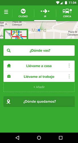
Citymapper began its journey in London, considered one of the cities with the longest tradition and greatest innovation in public transport. Since then, it has expanded its global presence to numerous cities in Europe, America, Asia, and Oceania. In Spain , the app is operational in the main metropolitan areas:
- Madrid: Complete integration of the metro, Cercanías Renfe (local trains) and EMT (municipal buses), with real-time information and multimodal route plans.
- Barcelona: Supports Metro, Rodalies, Ferrocarrils, urban buses, and alternatives such as bicycles or electric scooters, with all data updated in real time.
- Valencia and CastellónRecently incorporated, Citymapper covers all metropolitan and regional transport, from Gandía to Vinaròs and from Malvarrosa to Requena, as well as trams, metro, buses and commuter trains.
- EuskadiCoverage includes Bilbao, Donostia, Vitoria, Iparralde and the entire Basque transport network (metro, Euskotren, Renfe, tram, ferries).
In the rest of the world , Citymapper operates in over eighty cities, with support from New York, Paris, Berlin, Milan, Rome, San Francisco, Los Angeles, Philadelphia, Chicago, Washington D.C., Boston, Montreal, Toronto, Vancouver, Singapore, and many more. Expansion is ongoing, and you can view the full list and vote for your city on the official website.
Key advantages over other urban transport apps
While universal apps like Google Maps exist, Citymapper stands out for its specific focus on urban mobility and public transport . These are some of the advantages that make it a favorite among travelers and residents:
- Hyperlocal and up-to-date information from open data, official operators and contributions from local users.
- Instant comparison of routes and prices to choose the best option in terms of time, convenience and cost.
- Combination of all modes of urban transport and ecological or shared alternatives.
- Live Travel Assistant that guides you step by step, recalculating if there are any unforeseen changes or incidents.
- Offline functionality essential if you travel abroad or have poor mobile data coverage.
How to use and download Citymapper?
Citymapper is available for free . You can download the app from the Google Play Store for Android or the App Store for iOS. There's also a web version for planning routes from your computer. For optimal performance, the app requires an internet connection (Wi-Fi or mobile data), and it's recommended to have geolocation and GPS enabled for automatic location detection and real-time route tracking.
Once installed, simply select the city you're currently in or the one you're traveling to, enter your starting and destination points, and the app will suggest optimized alternative routes, with all the information about the journey, times, and possible combinations.
Plus, Citymapper is constantly updated to incorporate new cities, improved algorithms, and all the changes that occur in transportation networks. You can contribute with suggestions, report incidents, and share experiences directly from the platform.
Citymapper has established itself as the essential tool for travelers and city dwellers seeking efficiency, flexibility, and useful information when getting around town. Its ability to adapt to advancements in mobility and current needs makes it indispensable for both daily commutes and planning your next urban adventure. If you've already tried it or have any relevant experiences, please share them in the comments section to help others navigate the world more effectively.